Sanqingshan Geopark is located at the zone of conjunct the Yangtze and
Cathaysia paleoplates, the northwest edge of Huaiyu Terrain and the southeast
side of Qin-Hang paleoplate. Since the Mesozoic Era, Sanqingshan has been
located in the southeast part of the Eurasian plate and the western Pacific
continental margin active zone. It successively underwent the Caledonian Orogeny
and Indosinian-Hercynian Orogeny, the Yanshan Movement and Himalayan Movement as
characterized by block-faulting tectonics since the Mesozic Era.
(i) Folds
The Geopark is located at the core of Huaiyushan Anticlinorium, the
northwest part of Jiangxi Province. The multifolds in the rock layers are
developed. The main folds are as follows.
Huangtuling Anticlinorium: This is located at Huangtuling area in the
northwest of the Geopark and is a part of the larger Huangtuling-Kaihua
Anticlinorium. The main fold axis trends northeast, as do the plunging
subsidiary folds, each extending approximately 5 km. The axial plane of the fold
is nearly vertical with the northwest flank dipping at 30°-350°∠30°-75°, and the
relative gentle southeast flank at 120°-150°∠30°-60°. The core is made up of
Nanhua strata, and its flanks are composed of the Sinian-Ordovician strata. The
south flank is well exposed, forming some secondary anticlines and
synclines.
Huameishan Syncline: This is located in the northeast of the Geopark and
has a fold axis trending NE-SW. Its southwest end was uplifted against the side
of Huaiyushan granite body, while the northeast end extends in a direction of
67° through Yuantou. The northwest flank dips at 40°~60°, while the southeast
flank dips at 30°~50°. The core is made up of the early Ordovician Yinzhubu
Formation strata, while the flanks are composed of late Cambrian strata.
There are rich and various secondary folds, which are common in the Lower
Paleozoic and Neoproterozoic strata. Folds of differnt shapes and sizes are
visible on both the outcrop and the specimen scale, and they have an educational
and tourism value.
(ii) Faults
Faults are well developed within the Geopark (Table B-4). They mainly have
a NE, NNE and NW trend. The NE trending faults formed earliest, followed by the
NNE trending faults and the NW trending faults. Most of the faults are normal
and thrust faults.
The Fenglin-Zihu Fracture Belt, the Xiaoken-Bajiaowu Fault, and the
Egongling-Xiaxiken Fault are all normal faults. Sanqingshan was cut by them and
the main part formed a typical “triangle fault-block mountain” with the dips of
50°~80°. Speaking of the “triangle fault-block mountain” , the rocks or strata
inside of the “triangle fault-block mountain” are upthrown walls, while those
outside are downthrown walls. During the late period of Yanshan Movement, the
magma was subjected to intrusion, condensation and crystallization, forming
granites. About 20~30 million years ago, the Himalayan Orogeny, that is,
neotectonic movement occurred, as a result the mountain was uplifted. The
Sanqingshan area as a whole was also uplifted. During this period, the faults
underwent intense movements, Fenglin-Zihu Fracture Belt, Xiaoken-Bajiaowu Fault,
and Egongling-Xiaxiken Fault in particular were very active. The “triangle
fault-block mountain” centered Yujing Peak was uplifted once again, then Yujing
Peak became the highest peak in this area.
The features of main fractures of Sanqingshan Geopark
|
Strike
|
Name
|
Location
|
Extended scale
|
Attitude
|
Feature description
|
Property
|
Active period
|
|
Dip
|
Dip angle
|
|
NE
|
Changpeng Fault
|
Changpeng
|
>8km
|
NW
|
500
|
As it cut Sinian and Cambrian strata, some strata are lacking and became narrower. Along the fault there is a crushed zone, 2-6meters wide, consisting of squeeze lenticle, fracture rocks, structural brecciaand fault clay.
|
reverse fault
|
Caledonian
epoch
|
|
NE
|
Lengshuikeng-Xujia Village Fault
|
Lengshuikeng, Xujia Village
|
>2km
|
SE
|
600
~700
|
As it cut SE-oriated section, the NE end of the syncline composed of Paleozoic strata is lacking due to the lack of the strata of the SE flank. Along the fault there are silicification, striation and fault clay.
|
reverse fault
|
Indo-Chinese epoch
|
|
NE
|
Fenglin-Zihu Town Fracture Belt
|
Fenglin, Zihu Town
|
>6km
|
SE
|
500
~600
|
It is composed of a couple of NE faults with 50°-60° and the large ones are Fenglin-Dalongkou Fault and Xiabuling-Zihu Town Fault. The individual strike extends 12 km and the Fracture Belt cut the SE flank of Huangtuling Anticlinorium. The NW block is an upthrown block and the SE block isa downthrown block. Along the fault there are crushed zones (10-40m wide), cleavage zone, schistositized zone, crumple, flexure, etc. It is a multi-phase active fracture.
|
Mainly normal fault
|
Caledonian epoch- Himalaya
epoch
|
|
NNE
|
Xiaokeng-Bajiaowu Fault
|
Xiaokeng, Bajiaowu
|
Length>10km, Width:20~40m
|
NWW
|
600~
800
|
It cut not only the cap rock of the Indo-Chinese fold and Sanqingshan granite rock body, but the NE fault whose SEE block is an upthrown block and NWW block is a downthrown block. There are crushed zones (20-40m wide, ), striations and crumples.
|
normal fault
|
Yanshan epoch- Himalaya epoch
|
|
NW
|
E’Gongling- Xiaxikeng Fault
|
E’Gongling, Xiaxikeng
|
>13km
|
NE
|
700
|
It cut the core and SE flank of Huangtuling Anticlinorium and Lengshuikeng-Xujia Village NE-oriented fault, and horizontal displacement occured. The SW block is an upthrown block and NE block is a downthrown block. It contains structural breccia, silicified rock and cataclasite.
|
normal fault
|
Yanshan epoch- Himalaya epoch
|
|
NE
|
Wujia- Tucheng Fault
|
Wujia, Tucheng
|
>10km
|
SE
|
500
~600
|
It cut Ordovician strata and the SE flank of Huangtuling Anticlinorium. Along the fold there are a fault crushed zone, cleavage zone and schistositized zone where the rocks are broken with crumples and flexure.
|
reverse fault
|
Caledonian
epoch,
Indo-Chinese epoch, Yanshan epoch
|
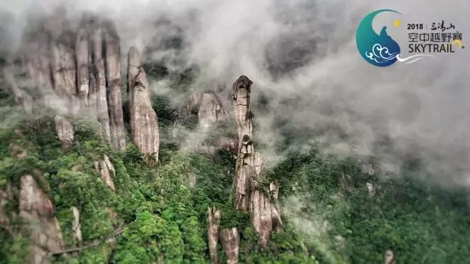
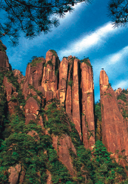
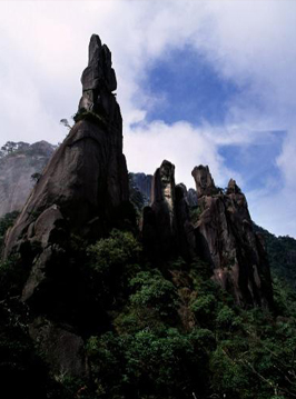
(iii) Joints
Joints occur in all kinds of geological bodies, especially in granite body
in the Geopark. Within the core zone there are two sets of vertical joints,
NE-NNE trending and NW trending, which together form a chess- board structure.
These structural features control most of the peak forests. The NE-NNE trending
joints tend to converge in the southwest and diverge towards the northeast,
occurring in abundance and forming a fan-shaped arrangement. These joints have
controlled the formation of the peak walls in the west (West Sea Peak Wall,
Screen to Firmament) and gorges in the south (Fushou Gate, A Gleam of Sky,
etc.). The NW trending joints gradually increase in number from north to south,
outcropping in groups. These are the main controlling structures of the peak
pillars in the central part of the Geopark, and the peak walls as well as gorges
in the southeast. In addition, there are a set of sub-horizontal joints which
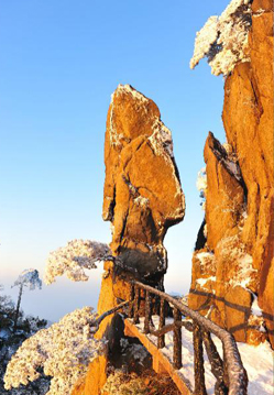
mainly control the formation of odd-shape stones. More specifically, these
provide definition to the peak walls and peak pillars, which have been further
shaped to form unusual figures by weathering and scouring.


 赣公网安备 36110202000032号