Because of the long-term role of the Earth’s internal and external
geological forces, the three sides of east, south and west of Sanqingshan
Geopark are steep, while the north and south sides are relatively flat. In the
central area, from the bottom to the top of the mountain, the horizontal
distance is 5 km, but the elevation rises from over 200 meters to 1,800 meters;
the height of the terrain is dramatically different. There are 10 major
landforms, including 5 genesis types: tectonic erosion, tectonic denudation,
runoff erosion and denudation, runoff accumulation, and gravitational collapse.
There are 5 morphological types, such as lower mountain, middle mountain, hilly,
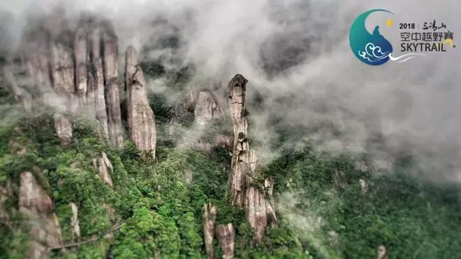
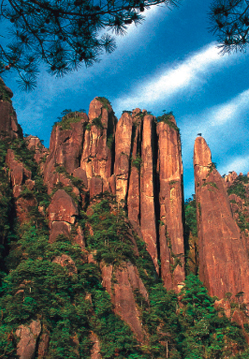
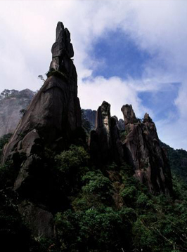
mountain basin and valley. The Geopark is a mountain area with a large granite
base in the center. The micro-landforms in the granite body are extensively
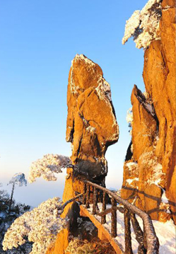
developed, with 11 diverse forms, i.e., peak, peak wall, peak cluster, pinnacle,
stone forest, peak pillar, stone cone, cliff, canyon, odd-shape stone, caves
(holes) and so on. The micro-landforms with outstanding scientific value, are
rarely seen in the granite, and a typical example of how to study and display
granite micro-landforms and their evolution process.
Erosion deep middle mountain landform
Centered in Yujing Peak, the peaks with an elevation of over 1,000 meters account for one third of the Geopark’s size. The cutting depth is from100 meters to 1,000meters. The main rocks are medium-grained-fine to medium-to coarse-grained biotite granite. The slopes are erosion slopes. There are many gullies and the mountain ridge is like a bevel-gear. As a whole, the east slope from Jinsha to Yujing Peak and the west slope from Hengyuan to Fenshui to Yujing Peak, combined with the south part, forming towering and overlapped mountain. The mean value of the slope gradients is greater than 45°. The east slope is more gentle than the west slope, while the south slope is more gentle than the north slope. As a result of crust uplift, gravitiational collapse and runoff erosion, the mountain is subject to cutting with a cut-density of 2~4 km/km2. The highest value is 4.75km/km2 in Hengyuan, while the lowest value is 0.55 km/km2 in Three Taoist Immortals’ Residence. According to the characteristics of the middle mountains area, the granite landforms include granite pillars (Sanqingshan granite area) , granite walls (around Yujing Peak and Yungai Peak) and peak forests (Yujing Peak and Nanqing Park).
Erosion low mountain landform
Its elevation is 500~1,000 meters, and the cutting depth is 100~500 meters;
shallow cut. The slope is generally over 45°, with v-shaped valley, the bottom
slope is 2°~5°. The erosion low mountain landform has the largest area in the
northeast and west sides of Sanqingshan. The majority of the rock is made up of
the Paleozoic Cambrian and the Ordovician. Example of this include the areas of
Shigulingtou in the northeast, and Pingxi and the Baxiandong in the south, where
the limestone is interlayered and lenticular, without strong erosion, and no
karst landform. Another planation surface lies between the east Fenshuiguan and
the west slope of Yujing Peak; it is about 700~800 meters above sea level, has
steep slopes, a crisscrossed valley, and a mist-capped waterfall in the cross
area of the valley and the fault. Yangqing Waterfall in the northwest slope, 10
meters high, 15 meters wide, falls along with a fault surface NW290° at a right
angle of 80 ° . The upper part is composed of the Sinian thermal metamorphic
keratology; while the lower part is composed of granite body.
Structural denudation valley landform
The marginal region of the Geopark, such as the areas of below the northern
Fenshui and the southern Fenglin, has an elevation of generally less than 500
meters, and only a few peaks are 500 meters high. The cutting depth is of
100~200 meters, with gentle slopes, V-shaped valleys, and an EW trending
ridge.
Runoff erosion and denudation accumulation landform
Due to Quaternary flood alluvial accumulation, runoff erosion and
denudation accumulation landform occurs in the areas of Shangfenshui,
Beifangtang, Shuangxi and Fenglin, Zihu, Tongfang to Houye. At the same time,
there are two typical mountain depressions. One is less than 450 meters high
above sea level; larger gravel with a diameter of 10~15 meters can often be
found in the depression. The largest gravel has a diameter of 30 meters, with
better roundness. Another is the Sanqingfudi Depression, 1,450 meters high above
sea level, with an area of over 100 mu, a rare basin on the top of the mountain.
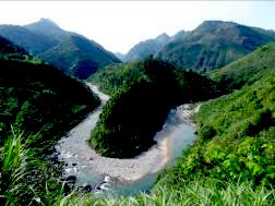
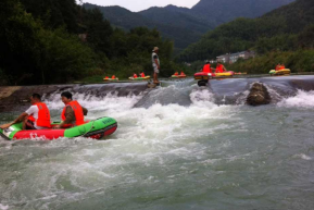
In the meanwhile, there are three mountain rivers, namely Jingsha River, Yuya
River and Fenshui River in the Geopark, and parts of the rivers are developed
for sightseeing and rafting.
 |
 |
| The scenery in the upper reach of Jingsha River |
Rafting in the middle reach of Jinsha River (Zihu Section) |
Mountain basin
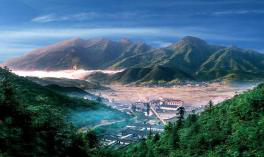
In the core area of the Huaiyushan area of the Geopark, the surrounding
areas are mountains with the elevation of over 1,000 meters. The central area is
a basin-shaped depression, with an average elevation of more than 900 meters,
covering an area of 6.5 km2. According to the experts from the Institute of
Geographic Sciences and Natural Resources Research of Chinese Academy of
Sciences, Huaiyushan Basin is the largest alpine basin in East China, and it is
also the highest and the most coollest summer resort with the largest visitor
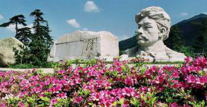
capacity in East China. In addition, it retains rich cultural heritage,
therefore it has now become a national youth education base.
 |
 |
| Alpine basin (Huaiyushan) |
National Youth Education Base (Fang Zhimin Memorial) |


 赣公网安备 36110202000032号